Difference between revisions of "Hennigan's Stead"
Jump to navigation
Jump to search
Tanklovesyou (talk | contribs) (Created page with "Category:Locations Category:Regions '''Hennigan's Stead''' is a constituent region of the New Austin Frontier territory. {{Location |name = Hennigan's St...") |
Tanklovesyou (talk | contribs) |
||
| Line 17: | Line 17: | ||
|previous = | |previous = | ||
|gravesites = | |gravesites = | ||
| − | |imagemap = | + | |imagemap = Hennigans-stead-map.jpg |
| − | |altmap = | + | |altmap = Hennigans-stead-map.jpg |
}} | }} | ||
Latest revision as of 19:39, 11 August 2022
Hennigan's Stead is a constituent region of the New Austin Frontier territory.
Description
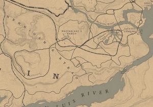
Hennigan's Stead is the eastern-most region of New Austin and borders the region of Cholla Springs to the west. The south border of the region is defined by the San Luis River, with the Lower Montana River to the north. The port town of Thieves Landing is just to the north of Manteca Falls. The area is defined by a steep plateau, striking cliffs, and a canyon to the north known as Pike's Basin.
Locations
- Brittlebrush Trawl
- Dixon Crossing
- Greenhollow
- MacFarlane's Ranch
- Manteca Falls
- Mason's Bridge
- Mescalero
- Montana Ford
- The Old Bacchus Place
- Pike's Basin
- Stillwater Creek
- Thieves' Landing
- Tree House

