Difference between revisions of "Río Bravo"
Jump to navigation
Jump to search
Tanklovesyou (talk | contribs) |
Tanklovesyou (talk | contribs) |
||
| (One intermediate revision by the same user not shown) | |||
| Line 6: | Line 6: | ||
{{Location | {{Location | ||
|name = Río Bravo | |name = Río Bravo | ||
| − | |image = | + | |image = Rio_bravo.jpg |
| − | |alt = | + | |alt = Rio_bravo.jpg |
|caption = | |caption = | ||
| − | |type = | + | |type = Semi-arid shrubland |
|state = [[New Austin Frontier]] | |state = [[New Austin Frontier]] | ||
|region = | |region = | ||
| Line 17: | Line 17: | ||
|previous = | |previous = | ||
|gravesites = | |gravesites = | ||
| − | |imagemap = | + | |imagemap = Rio bravo map.jpg |
| − | |altmap = | + | |altmap = Rio bravo map.jpg |
}} | }} | ||
Latest revision as of 19:38, 11 August 2022
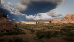
Río Bravo is a constituent region of the New Austin Frontier territory.
Description
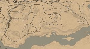
Río Bravo is the southernmost region of the territory and borders the regions of Cholla Springs to the northeast and Gaptooth Ridge to the northwest. A large portion of the southern border is defined by the San Luis River. Travel through the area is also extremely hazardous, due to the frequent cougar and wolf attacks that occur, particularly in the higher altitudes. The area is also sparsely populated compared to the other regions of New Austin and has no major settlements or towns aside from the abandoned Fort Mercer.

