Difference between revisions of "Cholla Springs"
Tanklovesyou (talk | contribs) |
Tanklovesyou (talk | contribs) |
||
| (One intermediate revision by the same user not shown) | |||
| Line 1: | Line 1: | ||
[[Category:Locations]] | [[Category:Locations]] | ||
[[Category:Regions]] | [[Category:Regions]] | ||
| − | '''Cholla Springs''' is a constituent region of the [[New Austin]] | + | '''Cholla Springs''' is a constituent [[region]] of the [[New Austin Frontier]] [[territory]]. |
Latest revision as of 17:41, 10 August 2022
Cholla Springs is a constituent region of the New Austin Frontier territory.
Description
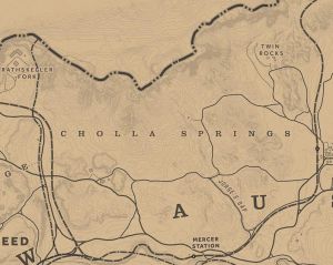
Cholla Springs is the center of New Austin, bordering the counties of Gaptooth Ridge to the west, Río Bravo to the south, and Hennigan's Stead to the east. A small portion of the South-Eastern border is defined by the San Luis River, and the Redemption Mountains are to its north.
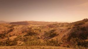
The area is a largely arid desert with a few shrubs and cactus. Most of the land is too arid and dry for farming, making cattle ranching a more preferable choice. Crime – particularly in the form of outlaw gangs – is prevalent, and so danger is common. The region consists of wide-open desert plains and low-lying hills with small rocky canyons and cliffs with jagged peaks. Trees are almost non-existent. The largest source of water in the region is Lake Don Julio to the south.
Aside from the town of Armadillo, the county is mostly rural, littered with a few small ranches and a train station.
Locations
- Armadillo
- Coot's Chapel
- Critchley's Ranch
- Crashed Airship
- Donkey Lady
- Hamlin's Passing
- The Hanging Rock
- Jorge's Gap
- Lake Don Julio
- Mercer Station
- Oddfellow's Rest
- Pleasance House
- Rattlesnake Hollow
- Ridgewood Farm
- Río del Lobo
- Riley's Charge
- Twin Rocks
- Two Crows
- Venter's Place

