Difference between revisions of "Commonwealth of West Elizabeth"
Tanklovesyou (talk | contribs) |
Tanklovesyou (talk | contribs) |
||
| (7 intermediate revisions by the same user not shown) | |||
| Line 1: | Line 1: | ||
[[Category:Locations]] | [[Category:Locations]] | ||
| + | [[Category:Territories]] | ||
| + | The <b>Commonwealth of West Elizabeth</b> (often referred to simply as West Elizabeth) is one of the five [[territories]] of Saint's Crossing. | ||
| + | |||
{{Location | {{Location | ||
|name = Commonwealth of West Elizabeth | |name = Commonwealth of West Elizabeth | ||
| − | |image = | + | |image = West-elizabeth-birds-eye.jpg |
| − | |alt = | + | |alt = West-elizabeth-birds-eye.jpg |
| − | |caption = | + | |caption = |
| − | |type = | + | |type = [[Territory]] |
|state = | |state = | ||
|region = [[Great Plains]], [[Tall Trees]], [[Big Valley]] | |region = [[Great Plains]], [[Tall Trees]], [[Big Valley]] | ||
| Line 17: | Line 20: | ||
|altmap = Westelizabeth-map.jpg | |altmap = Westelizabeth-map.jpg | ||
}} | }} | ||
| − | |||
| − | |||
==Description== | ==Description== | ||
| Line 28: | Line 29: | ||
The landscape progresses from rolling grasslands in the [[Great Plains]] region through snow-capped, impassable mountains around the edges of Tall Trees. To the north lies Big Valley, which falls under the foot of [[Mount Shann]]. The resemblance of Tall Trees persists northwards until near the vicinity of Strawberry where the elevation gets higher. The area is mountainous and slightly forested with patches of meadows surrounding the base of the mountain. | The landscape progresses from rolling grasslands in the [[Great Plains]] region through snow-capped, impassable mountains around the edges of Tall Trees. To the north lies Big Valley, which falls under the foot of [[Mount Shann]]. The resemblance of Tall Trees persists northwards until near the vicinity of Strawberry where the elevation gets higher. The area is mountainous and slightly forested with patches of meadows surrounding the base of the mountain. | ||
| − | |||
==Locations== | ==Locations== | ||
The following is an alphabetical list of the locations found in West Elizabeth: | The following is an alphabetical list of the locations found in West Elizabeth: | ||
| − | |||
<h5>Great Plains</h5> | <h5>Great Plains</h5> | ||
Latest revision as of 22:35, 11 August 2022
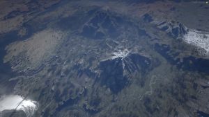
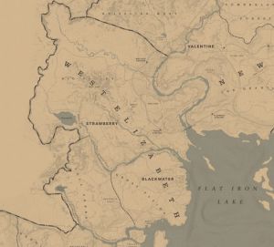
The Commonwealth of West Elizabeth (often referred to simply as West Elizabeth) is one of the five territories of Saint's Crossing.
Description
West Elizabeth is composed of three constituent regions: Tall Trees, Great Plains, and Big Valley. It is the second most modernized region of Saint's Crossing, with only Saint Denis in Lemoyne preceding it. There are two major settlements in West Elizabeth: Blackwater and Strawberry. There are also camps, ranches, and homesteads that dot the territory.
Geography
West Elizabeth is bordered by New Austin to the south, which its border is established by the Lower Montana River. The river empties through Thieves' Landing, then to the San Luis River. In the north, it is bordered by the Grizzlies West. Big Valley is bordered by The Heartlands, in New Hanover, to the east, in which its natural border is the Dakota River. Eastwards, Flat Iron Lake borders the rest of the territory.
The landscape progresses from rolling grasslands in the Great Plains region through snow-capped, impassable mountains around the edges of Tall Trees. To the north lies Big Valley, which falls under the foot of Mount Shann. The resemblance of Tall Trees persists northwards until near the vicinity of Strawberry where the elevation gets higher. The area is mountainous and slightly forested with patches of meadows surrounding the base of the mountain.
Locations
The following is an alphabetical list of the locations found in West Elizabeth:
Great Plains
Tall Trees
- Aurora Basin
- Bear Claw
- Circus Wagons
- Cochinay
- Dixon Crossing
- Evelyn Miller Camp
- Lower Montana River
- Manzanita Post
- Mason's Bridge
- Montana Ford
- Nekoti Rock
- Swadbass Point
- Tanner's Reach
Big Valley
- Appleseed Timber Company
- Bard's Crossing
- Beryl's Dream
- Black Bone Forest
- Dakota River
- Diablo Ridge
- Fort Riggs
- Hanging Dog Ranch
- Hawks Eye Creek
- Lenora View
- Little Creek River
- Lone Mule Stead
- Monto's Rest
- Mount Shann
- Old Tom's Blind
- Owanjila
- Owanjila Dam
- Painted Sky
- Pronghorn Ranch
- Riggs Station
- Shepherds Rise
- Stilt Shack
- Strawberry
- Taxidermist House
- Upper Montana River
- Valley View
- Vetter's Echo
- Wallace Overlook
- Wallace Station
- Watson's Cabin

